
Site Reconnaissance Survey for Mangroves Living Lab Monitoring Campaign
January 21, 2026
Ca Mau Province and Soc Trang Province, Vietnam
Researchers from ICOE and Thuy Loi University conducted the first reconnaissance survey for the Mangroves Living Lab project to identify suitable monitoring locations in the Mekong Delta. The field campaign evaluated mangrove conditions, shoreline changes, accessibility, and logistical requirements for installing long-term monitoring instruments.

The first reconnaissance survey of the Mangroves Living Lab project was conducted from 21 to 23 January 2026 by researchers from the Institute of Coastal and Offshore Engineering (ICOE) and Thuy Loi University. The field campaign covered several coastal locations in Ca Mau and Soc Trang Provinces to identify suitable monitoring sites for future field observations.
The primary objectives of the reconnaissance were to evaluate potential monitoring locations, assess shoreline and mangrove conditions, verify site accessibility, and determine the feasibility of deploying long-term monitoring instruments. During the survey, the team carried out field observations, photographed each site, recorded field notes, collected GPS coordinates, and assessed logistical and safety conditions for future measurements.
The reconnaissance covered seven candidate monitoring stations representing different coastal environments and mangrove conditions.

Hoa Binh Fixed Station (FS_HB_H_S0)

The team inspected the former water-level monitoring station at Hoa Binh. Although the station had previously supported long-term water level observations, the access bridge had already been removed, making the site inaccessible for future deployment. The location nevertheless remains valuable for long-term meteorological and tidal observations should access be restored.
Bac Lieu Wind Farm (XS_BL_H_S1)


The Bac Lieu site represents a healthy mangrove system located behind a hollow breakwater structure. Field observations showed that newly planted mangroves, mainly Avicennia (mangrove apple) species, have established successfully behind the breakwater, while additional restoration activities are currently being implemented on newly formed tidal flats.
Historical satellite imagery from 2019–2025 indicates significant environmental changes. Before the construction of the hollow breakwater, the mangrove belt was only about 30–70 m wide. Following construction in 2020 and subsequent restoration projects, newly planted forests expanded considerably inside the protected area. However, the original seaward mangrove belt showed little natural expansion during the same period.
Lai Hoa (XS_LH_D_S0)


Lai Hoa represents a mangrove area experiencing long-term coastal erosion. Analysis of shoreline changes between 2006 and 2024 revealed severe erosion between 2006 and 2014, with an estimated shoreline retreat of approximately 20 m per year.
A mangrove restoration project implemented around 2019 temporarily restored a mangrove belt approximately 100–150 m wide. Nevertheless, erosion continued between 2019 and 2024 at a similar rate, indicating that the coastline remains highly vulnerable.
Vinh Chau 1 (XS_VC1_D_S0)


Vinh Chau 1 was selected as the representative degraded mangrove site.
Field observations identified clear signs of coastal erosion. Researchers observed an abrupt drop in ground elevation immediately seaward of the mangrove edge, suggesting active shoreline retreat. Historical imagery also indicates mangrove fragmentation and conversion of coastal forests into shrimp ponds before partial restoration efforts began.
Although mangrove planting improved vegetation cover after 2014, mild erosion has continued in recent years.
Vinh Chau 2 and Vinh Chau 3 (XS_VC2_H_S0 & XS_VC3_H_S0)


The Vinh Chau 2 and Vinh Chau 3 sites represent healthy mangrove ecosystems with relatively stable shorelines.
Satellite image analysis shows that restoration activities between 2006 and 2019 successfully expanded mangrove coverage. Unlike the degraded sites, shoreline positions have remained nearly unchanged since 2019, indicating a stable coastal environment.
Field observations confirmed dense and healthy mangrove vegetation with favorable conditions for long-term monitoring.
Dai Ngai Fixed Station (FS_DN)


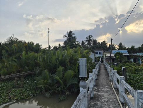
The reconnaissance also visited the Dai Ngai Hydrological Station, where a suspended sediment concentration (SSC) monitoring instrument has already been installed. The station offers valuable reference data that can support calibration and validation of future field measurements.
Selection of Representative Monitoring Sites
Based on field observations, accessibility assessments, and historical shoreline analyses, two representative cross-shore transects were selected for the main monitoring campaign:
XS_VC1_D_S0 — representative of a degraded mangrove forest affected by coastal erosion.
XS_VC3_H_S0 — representative of a healthy and stable mangrove forest.
These locations provide ideal conditions for comparing hydrodynamic and sediment transport processes under contrasting mangrove conditions.
Recommended Monitoring Configuration
The reconnaissance team proposed a comprehensive monitoring system for the upcoming field campaign.
The offshore measurement system will include Wave Buoys deployed at approximately 2 m and 5 m water depths together with an AWAC instrument to measure waves and longshore currents.
Nearshore observations will include pressure sensors installed outside and inside the mangrove forest, water-level loggers, RTK topographic surveys, and sediment sampling along approximately 2 km of the cross-shore transect. Additional sediment samples will be collected throughout the mangrove forest to investigate sediment transport and deposition processes.
The field campaign is expected to begin with a two-day instrument installation and testing period, followed by approximately two weeks of continuous monitoring.