
Hoa Binh
INTRODUCTION
Hoa Binh, a coastal district in Bac Lieu Province, plays a vital role in the province's coastal defense and marine economic development strategy. The area is notable for its sea dike system integrated with protective forest belts, which safeguard large areas of high-tech shrimp ponds and inland agricultural production. However, similar to neighboring regions, Hoa Binh faces localized erosion and pressure to maintain mangrove coverage amidst rapid urbanization and aquaculture expansion.
Hoa Binh 1 site, known as the wind farm resort locates south-east a distance of 12 km from Bac Lieu city center (Vĩnh Hậu A, Hòa Bình, Bạc Liêu).

Figure 1: Hoa Binh 1-Wind farm on the map, located at the south-east of Bac Lieu city center with a distance of 12 km
Hoa Binh 1 – Wind farm, now so-called Hoa Binh 1, is a tourist place where tourists and local people can visit a set of wind turbines at an offshore location. The furthest point allowed for visitors is about 6 km from land, which is always submerged. Hoa Binh 1 has both pros and cons for the future campaign.
Advantage
Hoa Binh 1 is a resort place surrounded by homestays and restaurants. It is recognized to be a good place for logistics. Hoa Binh 1 has a combination of mangroves, coastal areas, and offshore sites, making it a good place for measuring water level, waves, flows, sediment/sedimentation, and bio-mass.
The available devices for the project have their own cons, which are not waterproof. As a result, it needs to be installed at a high place from the bridge to the water surface, even in the low tide. Hence, optimizing designs for measurement plans will be more challenging.
Disadvantage
In the 6 km from land to offshore over a bridge, a mangrove width reaches about 150 m before approaching the coastal area. The gentle foreshore can be up to 1/1000, making the tidal area enormous. An advantage for setting up measurement devices on the bridge was recognized during the first attempt in the field, in which water level, wave gauges, and similar devices from Obscape can be set up without hiring a boat. The location is at a place where the water depth is 4 meters at low tide time. However, some devices from ICE which has water resistance can be installed at the brigde poles.
ACTIVITIES AND RESULTS
All measurements are installed and measured during the time mentioned above. There was a list of measurement activities in this period in which water level, wave measurement, and sedimentation were focused.
The team set the Level gauge and pressure-based wave gauges at the locations presented below.

Figure 2: Location of device installation in April and August 2024
April 2024

Figure 3. The level gauge for water level (a) and the Pressure-based wave gauge (b) were installed at the location presented in Figure 2

Figure 4. The suspended sediment concentration at 2 locations (a) and the Pressure-based wave gauge (b) were installed at the location presented in Figure 2
August 2024
The second fieldwork took place in Hoa Binh 1 – Wind farm after a careful consideration from the team in the logistics and network connections.
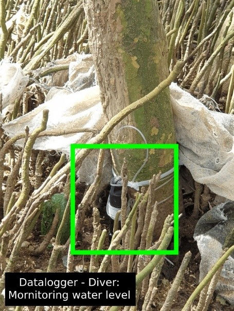
Similarly to the first trial in April, 2024, the team decided to set several stations at offshore positions, and a new nearshore position. The team also deployed a pressured measure devices, named Diver, to measure the inundation time in the mangroves.


(a)
(b)
(c)


(d)
(e)
(f)
Figure 5. Mornitoring stations: (a) Wave gauge; (b) Weather and Water level; (c) Water level in Mangroves. Installation Activities: (d) Validate elevation; (e) Weather station setting up; (f) Bed sediment sample
July 2025


Figure 6. Water level Measurement in Hoa Binh in July-2025
October 2025


Figure 7. Delegations at Hoa Binh Windfarm site in October - 2025